For all that
Stewart Island is now protected as
Rakiura National Park, it wasn’t always so. Parts were farmed, especially the area around and inland from Mason Bay on the island’s west coast. Here history (especially fire), poor drainage, and soil fertility influence the vegetation (Wilson 1986).
It was my privilege to walk twice across the island on successive days, each time with half the Lewis & Clark students (one student's blog here). This North-West Circuit Track is about 15 km, but not much up and down, and passes through several distinct plant communities. We were there in an unprecedented dry spell when it would have been possible and comfortable to walk the track in sneakers.
The flight in.
We had to make an early morning start to catch low tide for landing on the beach. The plane takes off from Halfmoon Bay and flies over Patterson Inlet to the tidal flats of Freshwater River (where our track ended each afternoon) and across the Scott Burn catchment traversed by the track, which was evident from the air. The end of the short flight is a steep descent over the extensive sand dune complex, a tight turn over the surf, and a thrilling landing on the wet sand.
 |
| Patterson Inlet |
 |
| Freshwater River |
 |
| The track in the Scott's Burn area |
 |
| Wheels almost down on the sand |
We were there at sunrise. It was cool in the shadow of the dunes, and there were meandering kiwi tracks in the wet sand. On the second day most of us were rewarded with a glimpse of a kiwi, following a bit of a trail through the marram grass.
 |
| Kiwi tracks, Mason Bay |
The dunes
The sand dune complex at Mason Bay follows the length of the beach and in places extends for a kilometre inland. The aptly, if unimaginatively, named Big Sandhill is a prominent feature. We followed Duck Creek inland through the sandhills and the vegetation got progressively more complex as we left the salt spray and wind behind, entering older more stable dunes with a little soil development.
 |
| Big Sandhill |
Introduced marram grass (Ammophila arenaria) dominates the seaward face and the dunes inland. It is a strong sand-binder—that’s probably why it was brought here—and makes steep-faced dunes, far steeper than the native sedge pingau (Ficinia spiralis), which is still present in a few sites. Not far inland a few natives appear: woollyhead (Craspedia uniflora), shore coprosma (Coprosma acerosa), Hydocotyle novae-zelandiae, and shore daphne (Pimelea lyallii).
 |
| Woollyhead, Craspedia uniflora |
 |
| Shore coprosma, Coprosma acerosa |
 |
| Pimelea lyallii, shore daphne |
 |
| Hydrocotyle novae-zelandiae |
Small damp patches between the sandhills support tiny herbs such as Limosella and stemless buttercup (Ranunculus acaulis).
Coastal low forest
 |
| Manuka, Leptospermum scoparium. |
On old stabilised sand near the Mason Bay Hut, we first entered the coastal low forest, with a dense canopy of manuka (Leptospermum scoparium) so thick that little light penetrated beneath. As a result there’s little understory and this forest would be a good location for filming the Mirkwood scenes for The Hobbit. Beside the track we saw a number of other plants though, Fuchsia excorticata with a few dried-up flowers, mutton-bird scrub (Brachyglottis rotundifolia), lancewood (Pseudopanax crassifolius) both juvenile and adult, putaputaweta (Carpodetus serratus), matipo (Myrsine australis) and young rimu (Dacrydium cupressinum).
 |
| Mingimingi, Leptecophylla juniperina |
Mingimingi (Leptecophylla juniperina) is occasional here, commoner later in the walk, and I thought it looked a bit brighter green, more open in habit, and perhaps pricklier than on the mainland.
Red tussockland
Beyond the farm’s homestead, now a heritage building, the track crosses a large red tussock grassland. Red tussock (Chionochloa rubra) would have been repeatedly burnt in the farming days to encourage fresh edible young growth. In the wetter patches, New Zealand flax (Phormium tenax) and a fern, Gleichenia dicarpa, flourish. Beside the track, blue sunbonnet orchids were opening as the sun’s rays reached them. We saw, and tasted, native mint (Mentha cunninghamii) here too.
 |
| Red tussock (Chionochloa rubra) with Gleichenia dicarpa |
 |
| Sunbonnet orchid, Thelymitra venosa |
 |
| Native mint, Mentha cunninghamii |
Two small native sundews (Drosera spathulata, D. binata) and a bladderwort (Utricularia) were features of this tussockland. All are insectivorous, able to gain their nitrogen supply from trapped insects in acid sterile bog soils. Although all living things must have nitrogen for building proteins and amino acids, and although nitrogen is a common element making up 80% of the atmosphere, no eukaryotes (plants, animals, fungi, and protists) have the ability to use atmospheric nitrogen directly without the help of bacteria. Surely that’s not an intelligent design.
 |
| Forked sundew, Drosera binata |
 |
| Bladderwort, Utricularia sp. |
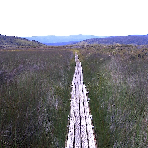
The swamp
In the middle of the track is a large swamp or wetland, and thanks to the Department of Conservation there’s a kilometre or two of boardwalk to cross it on. It’s deep and dominated by monocots: sedges and rushes and their ilk, like Leptocarpus similis (drier sites), Baumea rubiginosa (wetter sites), Juncus bulbosus, and Empodisma minus, but with Potamogeton in standing water, which is often stained with tannins.
 |
| The boardwalk |
 |
| Potamogeton in stained standing water |
In higher and drier patches, manuka, Coprosma propinqua, and toetoe (Austroderia richardii) have established. In other places the manuka has succumbed to poor drainage, leaving dead sticks poking skyward.
 |
| Plumes of toetoe (Austroderia richardii) with NZ flax (Phormium tenax) and coprosma. |
Regenerating forest
From the wetland to Freshwater Hut the track first follows the Scott Burn, which here looks to have been dug as a ditch at some time in the past because it follows a remarkably straight route. Tall manuka shelters developing young podocarps, rimu (Dacrydium cupressinum), thin-barked totara (Podocarpus cunninghamii), and miro (Prumnopitys ferruginea). In the understory, mingimingi, astelia, and coprosmas are flourishing as the manuka canopy opens up with age.
 |
| Astelia, Leptecophylla, and Blechnum under the manuka canopy at the Scott's Burn bridge |
A robin joined us for lunch, gaining access to insects in the leaf litter we had disturbed.
After the Scott Burn bridge the forest gives way to scrubby stuff, perhaps the most floristically diverse part of the track. The scrub is manuka again, with Dracophyllum longifolium and mingimingi; fire and poor drainage are the factors that explain its presence here.
 |
| Native St John's wort, Hypericum sp. |
 |
| Pentachondra pumila, a small heath |
 |
| Coral lichen, Cladia retipora. Brittle and white when dry, it becomes rubbery and slightly greenish when wetted, with its algal cells immediately starting to photosynthesise. |
 |
| A clubmoss, Lycopodium scariosum. The carbon that relatives of this plant fixed over millions of years during the Carboniferous formed the coal deposits of Europe and N. America. Its rapid burning over the last two centuries fueled the Industrial Revolution and drives anthropogenic global warming. |
Wet patches have Sphagnum bog. Sphagnum’s a remarkable plant. It’s a moss, but represents an early-diverging lineage among the mosses. Its main feature is the huge empty cells (leucocytes) in its leaves, which can absorb 25 times their weight of water. Thus dried Sphagnum is harvested for use in horticulture, making natural diapers and sanitary napkins, and was even used for wound dressings in World War 1. Environmentally, it can raise the water table of a bog, leading to domed bogs like low hills.
 |
| Sphagnum bog with dead standing manuka |
 |
| Sphagnum stems, called gametophores |
 |
| Forked sundew, Drosera binata, flowering in the Sphagnum. |
The end
The track ends at Freshwater Hut. The river here is tidal, but barely brackish this far up. On the first day it was hot and sunny (28 degrees in Invercargill) and we had drunk all our water before we got here. The sweet water in the hut’s tank was getting low, and we almost could have drunk it dry.
 |
| Lewis & Clark students relax at Freshwater Hut. |
 |
| Stewart Island water taxi on Freshwater River. |
The water taxi ride home was a pleasure for those that stayed awake, our driver stopped to show us a group of feeding little blue penguins in Patterson Inlet. And the evening swim at Halfmoon Bay’s Bathing Beach was a perfect and refreshing end to the day.
 |
| Kiwi, Mason Bay (I should stick to photographing plants, but this was the highlight and I couldn't leave it out) |
References.
Wilson, H. D. 1986: Plant communities of Stewart Island (New Zealand). New Zealand Journal of Botany Supplement: 1–80.


No comments:
Post a Comment